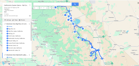
Top 12 Scenic Points in Eastern Sierra
If you wish to see Fall Foliage in California, you can follow this route to see the Aspen colors in California. You don’t need to fly to Colorado or East Coast this Fall. California’s Eastern Sierra Fall Colors is famous for the golden aspen colors. This is the route with 12 scenic points you would enjoy it yourself: start from Big Pine Canyon to Sagehen Summit.
Full map is available to download at the end of this article!
Why the Eastern Sierra is one of the best drives
- It’s 400 miles of continuous beauty from Big Pine to Topaz Lake
- You can camp almost anywhere because dispersed camping is legal in BLM Land
- It’s not crowded
- Every canyon offers something different
- The weather is nearly perfect: crisp mornings, warm afternoons, clear skies and lakes.
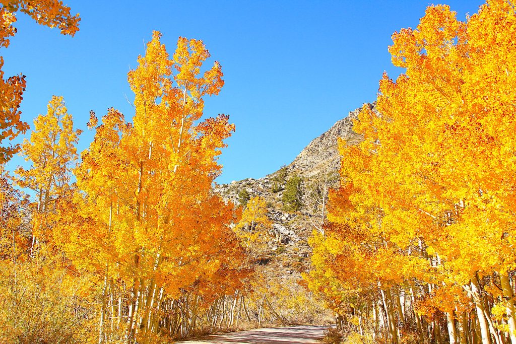
Stop 1: Big Pine Canyon

Location: West of Big Pine, off Crocker Street stretch to Glacier Lodge Road
How to Get There:
From Highway 395 in the tiny town of Big Pine, turn west on Crocker Street. Follow it as it becomes Glacier Lodge Road. You’ll climb steadily for about 10 miles through high desert landscape that suddenly bursts into aspen groves.
Road conditions: Paved all the way to the upper trailheads. Narrow in spots but totally manageable.
What You’ll See:
Two forks of Big Pine Creek (North and South), each with their own aspen displays. The South Fork has MORE aspens. The North Fork has bigger mountain views.
Time to spend: Half a day minimum
South Fork:
- Park at the South Fork trailhead (there’s a good-sized lot)
- Walk the trail toward Willow Lake (you don’t have to go all the way)
- Distance: First mile is the best shot for aspens
- Time: 1-2 hours roundtrip if you turn around at the aspen groves
- Photos: The willows turn burnt orange, the aspens are golden, the creek runs through it all
North Fork:
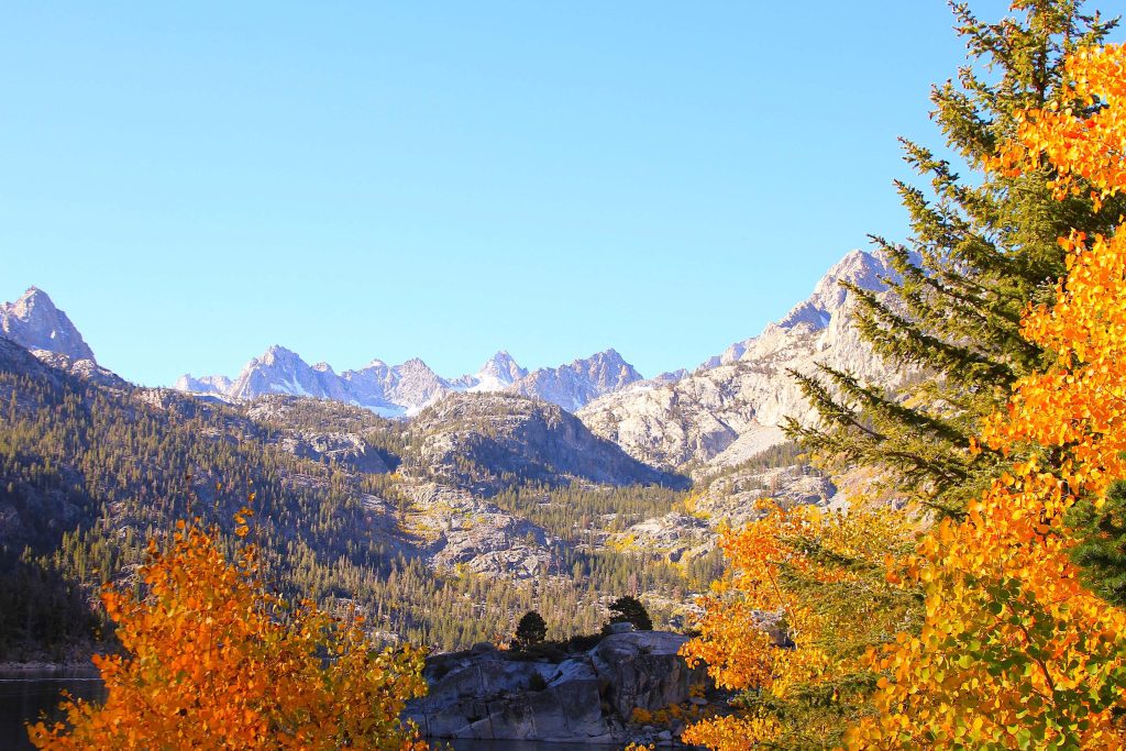
- Drive to the very end of the road (Glacier Lodge area)
- Park at Second Lake trailhead
- The trail: 4 miles roundtrip to Second Lake, but the aspens are in the first 2 miles
- Time: 2-3 hours if you go all the way to Second Lake
- Bonus: You can see Palisade Glacier from the upper trail (southernmost glacier in the US)
Where to Stay:
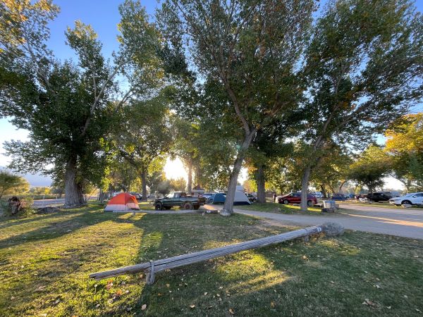
Big Pine Creek Campground (along the road up the canyon)
- Cost: $34/night
- Sites: About 30 sites, some along the creek
- Booking: reservation online
Or hotel in town: Starlight Motel in Big Pine ($75-95/night, basic but clean)
Where to Eat:
Your options:
- Copper Top BBQ (seriously good pulled pork, $12-15)
- Country Kitchen (breakfast, locals love it, $8-12)
- Stock up: Grocery store on Main Street (limited selection)
Pro tip: Fill your gas tank here. Big Pine has cheaper gas than Bishop or Mammoth.
Stop 2: City of Bishop
Location: Highway 395, mile marker 184
Bishop is the main town on this whole route. It’s where you restock, refuel, get good coffee, and remember what civilization feels like.
What to Do:
Visit Bishop City Park. Spend 2-3 hours wandering downtown.
Downtown Bishop:
- Main Street: Walkable, cute shops, murals everywhere
- Mule Days Museum: If you’re into random Western history
- Owens Valley Paiute-Shoshone Cultural Center: Worth 30-45 minutes
Best photo op in town: The “Welcome to Bishop” mural on Main Street (colorful, makes a good Instagram story)
Where to Stay:
Campground:
- Pleasant Valley Pit Campground: (just north of town, off 395)
- Brown’s Town Campground near downtown (this is the first campground I camped. I walked in, but you can call them ahead to book)
- Hotel option: Creekside Inn ($110-140/night, right on Bishop Creek, comfortable)
-
Brown’s Town Campground
Where to Eat:
- Breakfast: Erik Schat’s Bakery is famous for its sheepherder bread and cinnamon twists. I recommend getting there early to avoid the line. My favorite is the garlic bacon bread.I discovered this bakery on Google during my first solo trip and didn’t realize how popular it was. I arrived early in the morning for breakfast and found a long line of customers choosing fresh breads and pastries. With so many options, I wasn’t sure what to pick. I finally chose the garlic bacon bread, which was delicious and quite large. I couldn’t finish it all during my trip. I brought it home, and it’s even better warmed in the oven with some omelet on a sandwich. Yum! I returned to buy more bread several times on my trips to Yosemite, Lake Tahoe, and Death Valley.
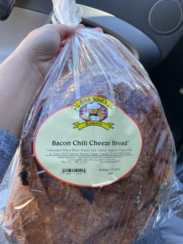
TIP: In my experience, the bread at the store is fresh and delicious. One time, I was worried they would run out of garlic bacon bread, so I called to reserve three loaves. I picked them up around 1 PM, and surprisingly, the quality wasn’t the same. I learned my lesson: just go to the store and choose the bread you want. I’m still not sure why it was different last time.
- Coffee: Black Sheep Coffee Roasters (best coffee on the entire 395 corridor)
- Lunch: Holy Smoke BBQ (Texas-style, massive portions)
- Dinner: Mountain Rambler Brewery (burgers, fish tacos, local brews)
- Fancy dinner: Rusty’s Whiskey Barrel (steaks, good cocktails)
- Groceries: Vons or Manor Market (stock up here, it’s cheaper than Mammoth)
Extra tips: There is meal-prepped at Manor Market
Stop 3: Bishop Creek Canyon
Location: West of Bishop on Highway 168, just 20 minutes from Bishop
How to Get There:
From Bishop, drive west on Highway 168 (Line Street becomes the highway). The road starts climbing immediately through high desert.
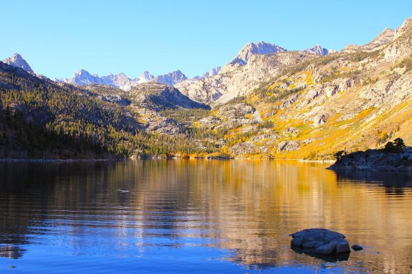
South Lake (Left Fork):
At about 15 miles up, you’ll hit a fork. Go LEFT for South Lake.
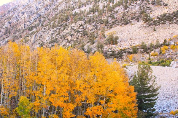
- The drive: 7 more miles of winding road through thick aspen groves
- Parking: Large lot at South Lake Walk: Path around the lake (mostly flat, 1 mile loop, 30-45 minutes)
- What you’ll see: South Lake surrounded by aspens and granite peaks. The Bishop Pass trailhead starts here.
- Time to spend: 2-3 hours
- Best photo spot: West side of the lake where you can see a lot of aspens
North Lake (Right Fork):
Go back to the fork and take the RIGHT toward North Lake.
WARNING: This road is NARROW and STEEP. If you’re nervous about mountain driving, this might freak you out. But it’s paved and totally worth it. I took a photo when I was driving uphill. It was narrow but it’s amazing when you looked down the road.
- The drive: 2.5 miles straight UP (you gain 1,000 feet of elevation fast)
- Parking: Small lot at North Lake (gets full by 10 AM on weekends). I could not find a parking spot so I kept driving to the dirt road and make a U-turn, waited for someone leave to get a parking spot. The best is coming early morning.
- What you’ll see: Smaller lake, WAY more dramatic peaks, aspens everywhere, fewer people.
- The walk: North Lake to the aspens is literally 5 minutes from the parking lot. Or hike toward Lamarck Lakes (2.5 miles roundtrip to the aspen groves).
- Time to spend: 3-4 hours if you hike
Lake Sabrina: beautiful and clear lake
On your way down, stop at Lake Sabrina (it’s right on Highway 168 before the fork).
- Why: Clear water. The aspens and mountain range reflect in the lake
- Time: 20-30 minutes for photos
- Walk: Short path along the shore
Where to Stay:
- Four Jeffrey Campground (on Highway 168, before the fork)
- Cost: $42/night
- Sabrina Campground (near Lake Sabrina): no need to reserve online,
- Cost: $34/night
- If camping’s full: Stay in Bishop (20 minutes away)
Stop 4: Buttermilk Recreation Area – The Boulder Playground
Location: West of Bishop on Buttermilk Road
How to Get There:
From Bishop, drive west on West Line Street (becomes Buttermilk Road). Follow the signs for Buttermilk Country (about 9 miles from town). The road turns to dirt for the last few miles (totally fine for regular cars).
What You’ll See:
Massive granite boulders scattered across the landscape like a giant’s playground. Pockets of aspens growing between the rocks.
- Time to spend: 1-2 hours
- The walk: No formal trails, just wander among the boulders. Bring a map or GPS, it’s easy to get turned around.
- Best for: Unique photos (aspens + boulders = very cool composition)
- When to go: Late afternoon for the best light on the rocks
Where to Camp:
There’s dispersed camping throughout Buttermilk (free, no facilities).
Stop 5: Round Valley
Location: East of Bishop on Highway 6
How to Get There:
From Bishop, drive EAST on Highway 6 toward Nevada. After about 3 miles, turn left on Round Valley Road. Follow it as it loops through ranch land and scattered aspens.
What You’ll See:
Wide-open valley with the Sierra Nevada rising dramatically to the west. Aspens along the creek bottoms. It’s pastoral and peaceful and completely different from the mountain canyons.
- Time to spend: 30-60 minutes
- Best time: Sunrise or sunset
- Optional Hiking: good trails are available in Pine Creek Canyon and Lower Rock Creek road.
Stop 6: Lower Rock Creek
Location: Off Highway 395, south of Tom’s Place
Elevation: 7,000 – 8,000 feet
GPS: Lower Rock Creek Road, Tom’s Place, CA
Most people blow right past Lower Rock Creek on their way to Rock Creek Canyon. Don’t make that mistake.
How to Get There:
About 24 miles north of Bishop on Highway 395, look for the turnoff to Lower Rock Creek (near Tom’s Place). Turn west and follow the road along the creek for about 3 miles.
What You’ll See:
Creek flowing through meadows lined with willows (burnt orange) and aspens (golden). It’s lower elevation than the upper canyon, so the colors peak slightly earlier.
- Time to spend: 30-45 minutes
- The walk: No formal trail, just park at pullouts and walk along the creek
- Best for: Quick photo stop, peaceful creek sounds.
Where to Eat:
- Tom’s Place Resort (right at the Highway 395 turnoff)
- Old-school mountain café
- Breakfast and lunch, $10-15
- The pancakes are HUGE
- Locals’ favorite
Stop 7: Rock Creek Canyon
Location: Rock Creek Road, off Highway 395
If Bishop Creek is the crown jewel, Rock Creek is the hidden treasure.
How to Get There:
Same turnoff as Lower Rock Creek, but keep driving PAST the lower area. The road climbs steeply for about 10 miles into the canyon.
Road conditions: Paved, but narrow and winding. Take your time.
What You’ll See:
Deep canyon carved by the creek, THICK aspen groves, multiple alpine lakes at the end of the road.
Time to spend: Half day to full day
The lakes at the end:
- Rock Creek Lake: Largest, boat rentals available, popular
- Heart Lake: Short hike from Rock Creek Lake (0.5 miles, easy)
- Long Lake: Just past Heart Lake, quieter
Where to Stay:
Multiple campgrounds along Rock Creek Road:
- Big Meadow Campground
- East Fork Campground
- Rock Creek Lake Campground
Or stay at: Rock Creek Lodge ($120-180/night, cabins, restaurant on-site)
Where to Eat:
Rock Creek Lakes Resort Restaurant (at the end of the road)
- Breakfast and lunch
- Basic but good
- The chili is solid
Stop 8: McGee Creek Canyon

Location: McGee Creek Road, off Highway 395
How to Get There:
About 30 miles north of Bishop on Highway 395 (just south of Mammoth), turn west on McGee Creek Road. Drive 3 miles to the trailhead.
What You’ll See:
Narrow canyon absolutely PACKED with aspens. It’s like driving through a golden tunnel.
- Time to spend: 1-2 hours
- The hike: McGee Creek Trail climbs to McGee Lake (8 miles roundtrip, hard). BUT you don’t need to hike far, the best aspens are in the first mile.
- Best photo spot: Right where the trail crosses the creek (about 0.3 miles in)
Where to Camp:
McGee Creek Campground (right at the trailhead)
- Sites: Small campground, maybe 20 sites
- Vibe: Quiet, surrounded by aspens
- Booking: First-come, first-served (get there early)
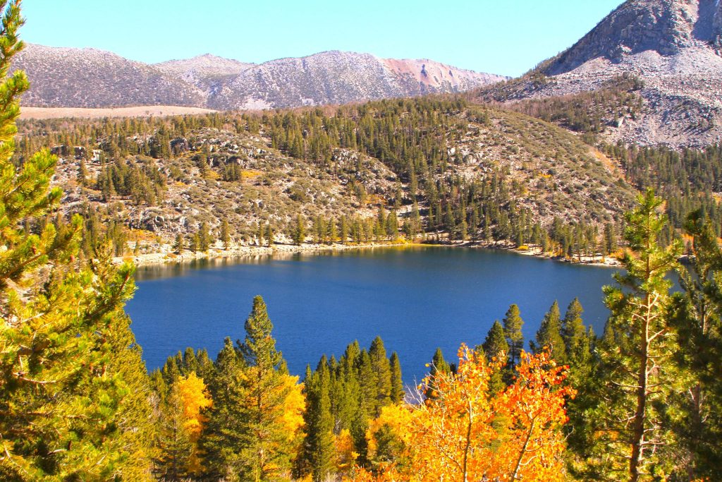
Stop 9: Convict Lake
Location: Convict Lake Road, off Highway 39
How to Get There:
Just south of Mammoth Lakes on Highway 395, turn west on Convict Lake Road. Drive 2 miles to the lake.
Parking: Large lot (fills up by 10 AM on weekends, arrive early)
What You’ll See:
Turquoise alpine lake surrounded by jagged granite peaks, with golden aspens lining the shore.
Time to spend: 2-3 hours
The loop trail:
- Distance: 2.8 miles around the lake
- Difficulty: Completely flat, wide path, easy
- Time: 1-1.5 hours at a casual pace
Best photo spots:
- West side of the lake (about 0.5 miles in)
- North shore where the aspens are thickest
- Early morning for mirror reflections
When to go: Sunrise is PACKED with photographers. I went at 3 PM and it was perfect, warm light, fewer people.
Where to Stay:
Convict Lake Campground (right at the lake)
- Booking: First-come, first-served
Or: Convict Lake Resort
Where to Eat:
The Restaurant at Convict Lake (fancy, $30-50 entrees, stunning views)
Stop 10: Mammoth Lakes – The Tourist Town
Location: Mammoth Lakes (town)
Mammoth is the biggest town on this whole route. It’s a ski resort town, so it’s got that vibe: outdoor gear shops, breweries, overpriced everything.
But the surrounding areas are GORGEOUS in fall.
What to Do:
- Minaret Vista
- Drive up Minaret Road (Highway 203 West) from town
- Pullout on the left with viewpoint
- What you see: The Minarets and Ritter Range (jagged peaks) with fall colors below
- Time: 15 minutes
- Best time: Sunrise
- Lakes Basin Loop: Drive the Lakes Basin Road (near Coldwater Campground) for access to:
- Lake Mary
- Lake George
- Horseshoe Lake (my favorite: short walk from parking, aspens everywhere)
- Time: 2-3 hours to hit all the lakes
- Sherwin Lakes Trail: South of Mammoth on 395, turn on Sherwin Creek Road.
- Hike: 4 miles roundtrip, some elevation gain
- What you see: Big aspen groves, mountain views
- Time: 2-3 hours
Where to Stay:
New Shady Rest Campground (in town)
Hotels: Everything’s expensive in Mammoth ($150-300/night).
- Mammoth Creek Inn ($150-200/night)
- Austria Hof Lodge (quirky Bavarian theme, $200+/night)
- I stayed one night at The Village Lodge. I booked it last minute for $170 because I couldn’t find an available campground or dispersed camping that night. I was nervous and tired. (Coming Soon: My story about my first trip, its challenges, why I booked a hotel last minute, and how I felt staying there alone.)
Where to Eat:
- Breakfast: Stellar Brew (coffee, pastries)
- Lunch: Good Life Café (healthy bowls)
- Dinner: Lakanuki
- Splurge: Petra’s Bistro
- Groceries: Vons
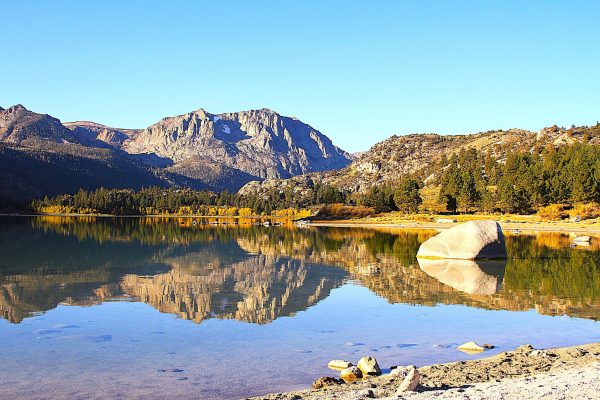
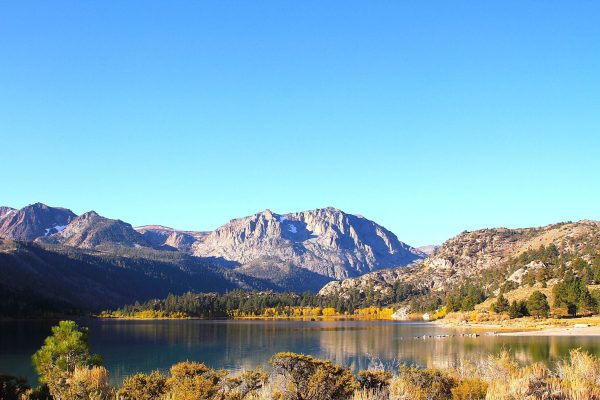
Stop 11: June Lake Loop
Location: Highway 158 (June Lake Loop)
This 16-mile loop might be the most beautiful stretch of road in California.
How to Get There:
About 15 miles north of Mammoth on Highway 395, take the southern entrance to Highway 158 (June Lake Loop). Drive it counter-clockwise (trust me on the direction).
The Four Lakes:
- Grant Lake:
- Quick pullout
- Good for photos
- 5-10 minutes
- Silver Lake:
- Small parking area
- Walk along the shore (15-20 minutes)
- Quieter than June Lake
- Aspens reflected in water
- Gull Lake:
- The aspens here are THICK around the entire shoreline
- Walking path along the edge (30-40 minutes)
- Best photo op on the entire Eastern Sierra
- June Lake:
- Biggest lake, small town with shops/cafés
- Walk around the lake (1.5 miles, easy, flat)
- Time: 1-2 hours for the walk + coffee break
Total time for the loop: Half day minimum
Where to Stay:
Oh Ridge Campground (on June Lake)
If camping’s full: Double Eagle Resort (cabins, $200-400/night, but lakeside location)
Where to Eat:
- Breakfast/Lunch: Eagle’s Landing Restaurant (at Double Eagle, open to public)
- Coffee: June Lake Brewing (yes, a brewery, but great coffee in the morning)
- Dinner: Carson Peak Inn (comfort food)
- Groceries: Tiny store in town (basics only)
Stop 12: Sagehen Summit – The Quiet Overlook
Location: Highway 395, between Lee Vining and June Lake
How to Get There:
Driving north on 395 from June Lake toward Lee Vining, you’ll crest Sagehen Summit. There’s a pullout on the right (east side) with interpretive signs.
What You’ll See:
Panoramic views of Mono Lake to the east, the Sierra crest to the west, and fall colors in the valleys below.
- Time to spend: 10-15 minutes
- Why stop: Perspective. You can see the whole landscape laid out. Plus, the elevation means you’re at eye level with distant peaks.
- Best time: Late afternoon (the light on Mono Lake is golden)
Free Travel Guide Map Download
I’ve created a travel guide map for California’s Eastern Sierra Fall Color, which includes 22 scenic points from Big Pine Canyon to Topaz Lake, near Lake Tahoe. You can fill out the form below and download it for your trip.
Hope you have fun time to visit Bishop in Fall. Please share your story and ideas when you come back from the trip. Happy Traveling!